 RSS
RSS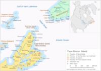
|
|
|
Cape Breton Island is part of the province of Nova Scotia, Canada. The 10311 km2 (10311000000 m2) island accounts for 18.7% of the total area of Nova Scotia. Although physically separated from the Nova Scotia peninsula by the Strait of Canso, it is artificially connected to mainland Nova Scotia by the 1385 m (4544 ft) long rock-fill Canso Causeway. The island is located east-northeast of the mainland with its northern and western coasts fronting on the Gulf of Saint Lawrence; its western coast also forming the eastern limits of the Northumberland Strait. The eastern and southern coasts front the Atlantic Ocean; its eastern coast also forming the western limits of the Cabot Strait. Its landmass slopes upward from south to north, culminating in the highlands of its northern cape. One of the world's larger salt water lakes, Bras d'Or ("Arm of Gold" in French), dominates the centre of the island. The island is divided into four of Nova Scotia's eighteen counties: Cape Breton, Inverness, Richmond, and Victoria. Their total population as of the 2001 census numbered 147,454 "Cape Bretoners"; this is approximately 16% of the provincial population. Cape Breton Island has experienced a decline in population of approximately 6.8% since the previous census in 1996. Approximately 72% of the island's population is located in the Cape Breton Regional Municipality (CBRM) which includes all of Cape Breton County and is often referred to as Industrial Cape Breton, given the history of coal mining and steel manufacturing in this area. The island contains five reserves of the Mi'kmaq Nation, these being: Eskasoni, Membertou, Wagmatcook, Waycobah, and Potlotek/Chapel Island. Eskasoni is the largest in both population and land area. |