 RSS
RSS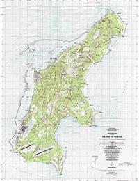
|
|
|
The Commonwealth's center of government is located in the village of Capital Hill on the island. As the entire island is organized as a single municipality, most publications term "Saipan" as the Commonwealth's capital. Located at latitude of 15.25° north and longitude of 145.75° east, about 120 mi (193.1 km) north of Guam, Saipan is about 12 mi (19.3 km) long and 5.6 mi (9 km) wide. It is a popular tourist destination in the Pacific. The western side of the island is lined with sandy beaches and an offshore coral reef which creates a large lagoon. The eastern shore is composed primarily of rugged rocky cliffs and a reef. Its highest point is a limestone covered mountain called Mount Tapochau at 1560 ft (475.5 m). Many people mistakenly believe Mount Tapochau to be an extinct volcano, but is in fact a limestone formation. To the north of Mount Tapochau towards Banzai Cliff is a ridge of hills. Mount Achugao, situated about 2 miles north, has been interpreted to be a remnant of a stratified composite volcanic cone whose Eocene center was not far north of the present peak. Besides English, the indigenous Chamorro language is spoken by approximately 19 percent of the inhabitants. The island also has many other large, strongly defined lingual and ethnic groups because of the large percentage of contract workers (60% of total population, as of 2001) from China, Bangladesh, the Philippines, Thailand, Vietnam, and Cambodia. In addition, a large percentage of the island's population includes first-generation immigrants from Japan, China, and Korea, and immigrants from many of the other Micronesian islands. The population figure being given as of 2001 is now out of date as a major portion of the population would have been present for the garment industry. While some garment workers remain working in other occupations more returned to their home countries, went to Guam or to the United States. The current Mayor of Saipan is Republican Donald G. Flores, who was sworn into office on January 11, 2010. |