Home | Former Subdivision | Dakota Territory
|
|
|
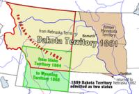
The Dakota Territory consisted of the northernmost part of the land acquired in the Louisiana Purchase of the United States. The name refers to the Dakota branch of the Sioux tribes which occupied the area at the time. Most of Dakota Territory was formerly part of the Minnesota and Nebraska territories. When Minnesota became a state in 1858, the leftover area between the Missouri River and Minnesota's western boundary fell unorganized. When the Yankton Treaty was signed later that year, ceding much of what had been Lakota land to the U.S. Government, early settlers formed an unofficial provisional government and unsuccessfully lobbied for United States territory status. However, it wasn't until three years later when soon-to-be-President Abraham Lincoln's cousin-in-law, J.B.S. Todd, personally lobbied for territory status that Washington formally created Dakota Territory. It became an organized territory on March 2, 1861. Upon creation, Dakota Territory included much of present-day Montana and Wyoming; by 1868, creation of new territories reduced Dakota Territory to the present boundaries of the Dakotas. Territorial counties were defined in 1872, including Bottineau County, Cass County and others.The territorial capital was Yankton from 1861 until 1883, when it was moved to Bismarck. The Dakota Territory was divided into the states of North Dakota and South Dakota on November 2, 1889. The admission of two states, as opposed to one, was done for a number of reasons. The two population centers in the territory were in the northeast and southeast corners of the territory, several hundred miles away from each other. On a national level, there was pressure from the Republican Party to admit two states to add to their political power in the Senate. A century later, with the populations of the two states at low levels, there were discussions of reuniting them as "Dakota", but this has never been seriously considered. |


 RSS
RSS