|
Big Stone Lake is a long, narrow freshwater lake and reservoir forming the border between western Minnesota and northeastern South Dakota in the USA. The lake covers 12,610 acres (51 km2) of surface area, stretching 26 miles (42 km) from end to end and averaging around 1 mile (2 km) wide, and at an elevation of 965 feet (294 m) is the lowest point in South Dakota. Big Stone Lake is the source of the Minnesota River, which flows 332 miles (534 km) to the Mississippi River. Flow from the lake to the Minnesota River is regulated by the Big Stone Lake Dam, located at the southern end of the lake. The lake is fed by the Little Minnesota River at its north end, which flows through the Traverse Gap. Big Stone was formed at the end of the last ice age when glacial Lake Agassiz drained through the gap into Glacial River Warren. The valley of that river now holds Big Stone Lake.
Two state parks are located at the lake: Big Stone Lake State Park in Minnesota and Hartford Beach State Park in South Dakota. The two parks provide picnic, boat launching, trail, and camping facilities. An educational center at the lake is part of the Minnesota state park. Several vacation resorts are located along the shores of Big Stone Lake as well. Visitors are attracted to the lake especially for its fishing: walleye, northern pike, and bluegills are all popular game fish with anglers, and the lake contains over 30 other species. There are 12 public accesses for fishing use. The lake is stocked once every two years with 7,000,000 walleye fry.
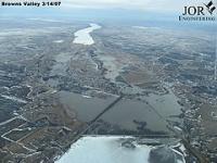
The communities of Ortonville, Minnesota, and Big Stone City, South Dakota, are located at the southern tip of the lake; Browns Valley, Minnesota, is located at the northern tip.
|
|
 RSS
RSS